


Rain Radar app icon

Rain Radar Live weather radar

Live rain maps, snow radar, lightning activity, storm tracking and short-term precipitation timing for iPhone.

Download Rain Radar on the App Store
Rain Radar live precipitation map screen
Live Weather RadarAnimated rain maps
Lightning TrackerStrike activity
Storm TrackerSevere weather
Rain TimingShort-term outlook

See where rain is moving before it reaches you.

Rain Radar is for the moments when a normal forecast is too vague. Instead of reading a percentage and guessing, you can watch live weather radar animation, see where precipitation is moving, and understand whether the next shower is heading toward your location.

The app is useful for commuting, walking, cycling, deliveries, outdoor work, school pickup, travel days and stormy weekends when rain timing matters more than a generic daily summary.

A moving rain map gives better context than a static weather icon. You can look at the shape of a rain band, the direction it is traveling, how quickly it is changing, and whether heavier precipitation is forming nearby.

Snow radar and mixed precipitation layers help during winter weather, when a simple forecast can hide the difference between light rain, heavier snow, or a system that is changing as it moves. The visual scale makes those differences easier to scan quickly.

Lightning activity adds another layer of storm awareness. When strike clusters appear near a rain core, Rain Radar becomes a practical storm tracker for deciding whether to delay outdoor work, change a route, or keep watching the map before leaving.

Rain Radar works as a personal weather tracker for real-time updates, accurate forecasts and detailed radar imagery. That positioning is useful for people who want a focused map before commuting, traveling, working outside or planning around fast-changing weather.

Instead of separating forecast, map and alerts into unrelated screens, Rain Radar keeps precipitation, interactive map controls and severe weather context close together. You can zoom into your location, check another city, follow weather patterns around the world and scan detailed weather information such as temperature, humidity, wind speed and UV index.

Custom rain and storm alerts make the app useful even when it is not open. If severe weather, incoming rain or changing storm conditions matter to your plans, notifications can bring the radar back into focus at the right moment.
Open the live radar and understand the next hour faster.

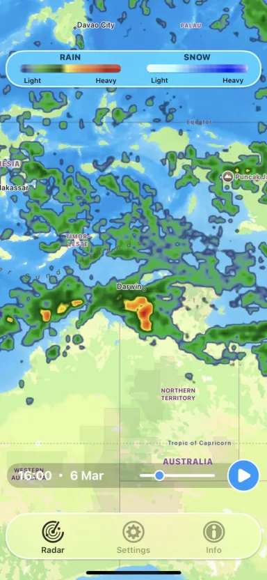
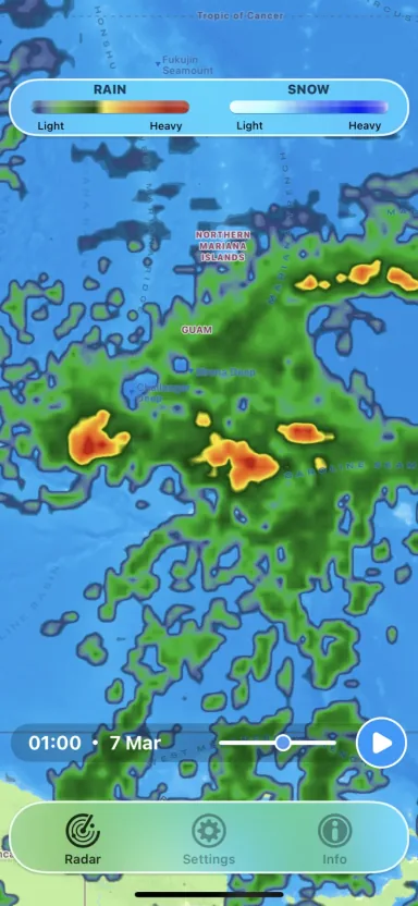
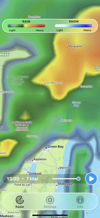
Rain Radar keeps the moving weather layer, intensity scale and timeline visible, so the rain map tells the story quickly.

Rain map colorsGreen, yellow and red areas help separate light showers from heavier rain cores.
Rain and snow legendThe top scale makes it clear whether you are looking at rain, snow or mixed precipitation.
Radar timelineUse the time slider and play control to see where precipitation is moving next.
Map contextCity labels, roads, terrain and satellite-style backgrounds make storm position easier to understand.

Use Rain Radar when storm tracking and timing matter.

Rain Radar is strongest when you need practical timing: leave now, wait fifteen minutes, change a route or keep watching a storm line.

Before leaving

Open the map before a walk, commute or school run to see whether showers are close enough to matter.

During storms

Follow precipitation bands, storm movement and lightning clusters while weather changes around your location.

Outdoor work

Use the radar view to plan breaks, deliveries, site work or route changes during unstable weather.

Weekend plans

Check whether a rain band is passing through quickly or settling in before you leave for a hike, match or event.

Travel days

Zoom out to compare storm lines across regions and understand what is happening along a route.

Snow checks

Use the snow layer and intensity scale when winter precipitation starts mixing into the forecast.

A live weather radar app for people who need the map now.

Rain Radar does not bury the map behind a dashboard. The main experience is a full-screen precipitation view with a clear rain and snow scale, a play button for motion, and a timeline for checking how the weather is changing.

That makes it useful when you already know the forecast is unsettled and you want a better answer than "chance of rain." You can compare the shape, speed and direction of precipitation bands instead of guessing from a single percentage.

Watch precipitation move across the live radar map.

The main screens keep precipitation, map controls and timing visible so the app stays fast to read when weather is moving.

Rain Radar live precipitation map over northern Australia
Rain Radar precipitation layer near Guam
Rain Radar storm map near Green Bay

Rain Radar FAQ

Quick answers about live weather radar, rain maps, lightning and platform availability.

What is Rain Radar used for?

Rain Radar is a live weather radar app for tracking rain maps, snow radar, lightning and storm movement so you can see when weather is approaching your location.

Does Rain Radar show lightning activity?

Yes. Rain Radar includes live lightning detection and strike clusters together with precipitation radar and storm alerts.

Is Rain Radar available for Android?

No. Rain Radar is currently available for iPhone on the App Store. Weather Now and 3D Earth & Moon still have Android versions.

Does Rain Radar show snow?

Yes. The map includes rain and snow intensity scales so winter precipitation is easier to separate from regular rain.

Can I use it while traveling?

Yes. You can zoom the map from local streets to regional views, which helps when you want to understand weather along a route or around a destination.

Why use a dedicated rain radar instead of a full weather app?

A dedicated radar app keeps live weather radar, rain timing, storm direction and lightning activity front and center.